• Home
  • Games
    Action-adventure Simulation Business Role Playing Sports Competition Casual Intelligence Card Strategy Music Rhythm Text Puzzle Flying Shooting Love Development
  • Apps
    Business Office Newsletter Social Life Entertainment Online Shopping Practical Tools Travel Financial Management Educational Learning Information Reading Sports and Health
  • Articles

English 中文(简体) 中文(繁体) 한국어 日本語 Português Español Русский العربية Indonesia Deutsch Français ภาษาไทย
Home Apps Practical Tools Marine Barometer
Marine Barometer

Marine Barometer

1
2
3
4
5
Download
  • Version 1.1
  • Category Practical Tools
  • Package Name com.starpath.marinebarometer
  • Update Time July 16, 2025
  • Size 34.74MB
About this app

Designed for mariners

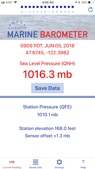
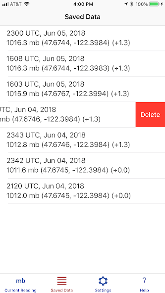
Marine Barometer is a barometer sensor interface that is uniquely designed to meet the needs of mariners who rely on accurate atmospheric pressure for weather routing and the evaluation of weather maps. Pressure readings can be manually saved permanently along with the latitude, longitude, and time of the reading. If a sensor offset has been applied, that value is also stored with each recorded pressure. These recorded pressures can then at the navigator's convenience be transferred to the vessel's printed logbook.

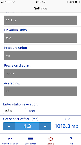
The GPS sensor is accessed for latitude and longitude only. The elevation of the sensor (your iOS device that includes a barometer) above sea level must be entered manually. Elevation values from the GPS are not accurate enough for the intended application.

A sliding average of the pressure displayed over the past 14 seconds can be engaged to account for the change in sensor height in the presence of waves and swells at sea so that an accurate sea level pressure can be obtained.

The concept of sea level pressure is explained along with how it is determined from the sensor reading.

Instructions are provided on how to check the calibration of the sensor, and a sensor offset can be applied as needed. Links to sources of accurate sea level pressure are included. Sources of accurate elevation are included for use on land.

The standard units for marine applications are millibars (mb) or hectoPascals (hPa). The main pressure display can also be set to inches of mercury, millimeters of mercury, or kiloPascals. However, because the primary reference pressures that would be used to check the sensor calibration are in mb, the sensor calibration must be set using millibar units.

Reference links are provided for learning more about the tactical use of pressure for weather forecasting and weather map evaluation. Discounts are offered for barometer related reference books.

What's New in the Latest Version 1.1

Last updated on Dec 27, 2023 Minor updates
Download(34.74MB)
Users also viewed
  • Snowstorm Wallpaper

    Snowstorm Wallpaper

    1.01 August 20, 2025
  • AS AntiHacker

    AS AntiHacker

    2.36 August 19, 2025
  • Laptop Keyboard Modern Black

    Laptop Keyboard Modern Black

    1.279.13.95 August 19, 2025
  • Hipster Temp

    Hipster Temp

    1.1.6 August 19, 2025
  • My Home theme - Black neon

    My Home theme - Black neon

    1.0 August 19, 2025
  • Front Elevation Design

    Front Elevation Design

    1.7 August 19, 2025
  • Hide Files & Folders

    Hide Files & Folders

    2.1 August 18, 2025
  • Pilot Suit

    Pilot Suit

    1.0 August 18, 2025
  • PocketInvEditor

    PocketInvEditor

    1.17 August 17, 2025
  • 100 Patio Designs

    100 Patio Designs

    1.0 August 17, 2025
  • WeSync

    WeSync

    8.0.16 August 16, 2025
  • Volume Sync

    Volume Sync

    1.0.1 August 16, 2025
  • World weather widget&Forecast

    World weather widget&Forecast

    16.6.0.6271_50157 August 16, 2025
  • KVOA Weather

    KVOA Weather

    5.17.508 August 16, 2025
  • Smart Calendar

    Smart Calendar

    2.0.0 August 16, 2025
About Privacy Policy Terms of Service Cooking Policy

© Copyright 2017-2025 downzr.com