• Home
  • Games
    Action-adventure Simulation Business Role Playing Sports Competition Casual Intelligence Card Strategy Music Rhythm Text Puzzle Flying Shooting Love Development
  • Apps
    Business Office Newsletter Social Life Entertainment Online Shopping Practical Tools Travel Financial Management Educational Learning Information Reading Sports and Health
  • Articles

English 中文(简体) 中文(繁体) 한국어 日本語 Português Español Русский العربية Indonesia Deutsch Français ภาษาไทย
Home Apps Travel Infis GPS Mobile
Infis GPS Mobile

Infis GPS Mobile

1
2
3
4
5
Download
  • Version 1.31.59
  • Category Travel
  • Package Name klient.infis
  • Update Time December 13, 2024
  • Size 2.21MB
About this app

Infis GPS Mobile – car, fleet, localization, reports, routes, fuel usage.

Localization and logistics system (AVL) for mobile devices with Android OS.

The app is fully integrated with Infis main system, share identical features, and it is a useful tool while the system user have no access to the PC. The app provides all data collected in the main system (GPS data and data from terminals inputs). Dynamic menu provides easy access to vehicles groups and its detailed data, on-line fleet movement monitoring map module and reports module.

Note! For poperly Android device localization (in relation to a monitored vehicle) it is required to enable 'use wireless networks' in 'location and security' settings in Android device.

Provided functionalities and data:

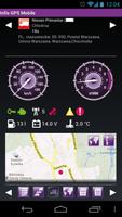
• real-time vehicle localization with info about last data transfer,

• movement status indication (drive, stop, parking, alarm, displacement),

• GPS/GSM signal, jamming, warnings and alarms indication,

• data from GPS device: speed, RPM, ignition status, engine status, voltage, tachograph status, fuel level, temperature in isothermal containers etc.

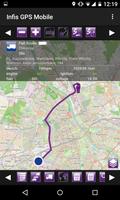
• last route indication (also during car movement),

• Infis GPS Mobile user localization in relation to a monitored vehicles.

a) based on mobile networks - every 300m and every 30 seconds.

b) based on GPS signal - every 10m and every 5 seconds.

c) baser on wireless networks - permanent.

• different map types OSM

• additional vehicle group named ‘current monitoring’ (user can add to this group any objects from other groups),

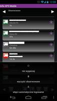
• last 48 hours reports handling: routes report, tachograph-vehicle report, fuel consumption report (data on digital map and graphs,

• reports history handling,

• vehicle search (by name).

More information about Infis system and mobile application is available on www.infis.pl

What's New in the Latest Version 1.31.59

Last updated on Jun 20, 2018 Informacje o nowej aplikacji.
Download(2.21MB)
Users also viewed
  • Digital speedometer: Digivel

    Digital speedometer: Digivel

    1.7.12 July 8, 2025
  • Moises Pro

    Moises Pro

    1.1.2 July 8, 2025
  • London Bus & Underground

    London Bus & Underground

    2.2 July 8, 2025
  • Surface Languages Swahili

    Surface Languages Swahili

    2.0 July 8, 2025
  • Track SEPTA

    Track SEPTA

    1.4.12 July 8, 2025
  • Planarry Last Mile

    Planarry Last Mile

    3.8.0 July 8, 2025
  • Zuver - Your Driver On Demand

    Zuver - Your Driver On Demand

    2.2 July 8, 2025
  • Numeri Telefonici

    Numeri Telefonici

    1.2.0 July 8, 2025
  • GeoRadar

    GeoRadar

    1.6.2 July 7, 2025
  • London Bus Time

    London Bus Time

    1.0 July 7, 2025
  • Night Earth

    Night Earth

    4.3.1 July 7, 2025
  • Trainsity Bangkok

    Trainsity Bangkok

    3.10.313 July 7, 2025
  • Car's Units Converter

    Car's Units Converter

    1.2.2 July 7, 2025
  • A Better Routeplanner (ABRP)

    A Better Routeplanner (ABRP)

    5.7.1 July 7, 2025
  • Hawaii Aloha

    Hawaii Aloha

    4.7.0.6 July 7, 2025
About Privacy Policy Terms of Service Cooking Policy

© Copyright 2017-2025 downzr.com