• Home
  • Games
    Action-adventure Simulation Business Role Playing Sports Competition Casual Intelligence Card Strategy Music Rhythm Text Puzzle Flying Shooting Love Development
  • Apps
    Business Office Newsletter Social Life Entertainment Online Shopping Practical Tools Travel Financial Management Educational Learning Information Reading Sports and Health
  • Articles

English 中文(简体) 中文(繁体) 한국어 日本語 Português Español Русский العربية Indonesia Deutsch Français ภาษาไทย
Home Apps Practical Tools easyAIS
easyAIS

easyAIS

1
2
3
4
5
Download
  • Version 1.5.5
  • Category Practical Tools
  • Package Name com.stentec.easyAIS
  • Update Time April 19, 2026
  • Size 457.44KB
About this app

Free AIS radar for easyTRX Wifi. Try our new WinGPS Marine for save navigation.

“easyAIS” is a free AIS real-time vessel positioning tool designed for the use on AIS receivers with WiFi connectifity.

The Automatic Identification System (AIS) is a maritime transponder/receiver system defined by the IMO (International Maritime Organisation).

AIS main objectives are to improve maritime safety and to protect the maritime environment.

Practically, AIS

•assists collision avoidance (AIS ship-to-ship)

•enables ports and coastal states to identify ships and to manage and supervise the traffic in their waters (AIS Coast station, VTS)

•helps to resolve the difficulty of identifying ships when not in sight (e.g. at night, in radar blind arcs or shadows or at distance)

By means of special VHF transceiver cruise data will be exchanged in short terms automatically. The treatment has a worldwide standard and runs every where. So vessels who use AIS devices from different companies will „see“ each other.

AIS enables to view over obstacles and complements radar. Acording to the antenna instalation hight an AIS station has got a transmission range about 20 to 30 nautical miles.

With the “easyAIS” app by the Weatherdock AG, all AIS targets within range are displayed relative to the user's position.

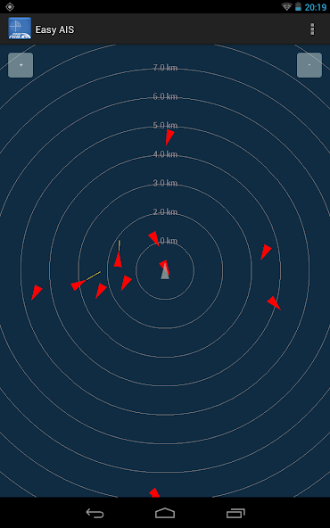
Main screen after starting the app is a virtual radar screen showing the AIS targets in relative position to you

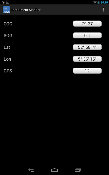
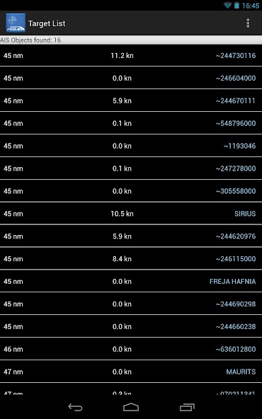
Just tapping the screen on an AIS target brings you to a list with all transmitted details of this target, e.g. GPS position, corse over ground, speed over ground, ship name, call sign, length, width, draft, port of registration …

“easyAIS” works by getting AIS data via WiFi from the AIS receiver or transceiver aboard. Without a running AIS

Notice:

“easyAIS” should not be used for navigational purposes!

What's New in the Latest Version 1.5.5

Last updated on Nov 23, 2015 12/8

- Running more stable.
- Minor bufixes.

22/7

- Bugfix on TCP Settings screen freezing.

15/7
- SART Targets are now clickable. Test-SART apears as green.
- AIS Target color selection. Default set to yellow.
Download(457.44KB)
Users also viewed
  • Erfurt

    Erfurt

    4 April 18, 2026
  • Devo Levar Meu Guarda-Chuva?

    Devo Levar Meu Guarda-Chuva?

    0.0.1 April 18, 2026
  • Dinosaur Kingdom

    Dinosaur Kingdom

    1.2 April 17, 2026
  • WorkLight Flashlight App

    WorkLight Flashlight App

    1.0 April 17, 2026
  • DPRRGSP

    DPRRGSP

    1.0 April 17, 2026
  • Orion Keys Live Wallpaper Free

    Orion Keys Live Wallpaper Free

    1.2 April 17, 2026
  • PROSPERA

    PROSPERA

    1.0 April 17, 2026
  • bathed in tears k

    bathed in tears k

    4.0 April 16, 2026
  • ANONdroid

    ANONdroid

    00.00.030 April 15, 2026
  • Clicker Counter

    Clicker Counter

    0.10 April 14, 2026
  • Koi Wallpapers

    Koi Wallpapers

    1.1 April 14, 2026
  • Do It Yourself - DIY Ideas

    Do It Yourself - DIY Ideas

    1.3 April 13, 2026
  • MareaChioggia2.0

    MareaChioggia2.0

    1.0 April 13, 2026
  • Armenia wallpapers

    Armenia wallpapers

    60 April 13, 2026
  • Lightning Launcher - Deutsch

    Lightning Launcher - Deutsch

    20 April 13, 2026
About Privacy Policy Terms of Service Cooking Policy

© Copyright 2017-2026 downzr.com