• Home
  • Games
    Action-adventure Simulation Business Role Playing Sports Competition Casual Intelligence Card Strategy Music Rhythm Text Puzzle Flying Shooting Love Development
  • Apps
    Business Office Newsletter Social Life Entertainment Online Shopping Practical Tools Travel Financial Management Educational Learning Information Reading Sports and Health
  • Articles

English 中文(简体) 中文(繁体) 한국어 日本語 Português Español Русский العربية Indonesia Deutsch Français ภาษาไทย
Home Apps Practical Tools Altitude
Altitude

Altitude

1
2
3
4
5
Download
  • Version 2.09a9
  • Category Practical Tools
  • Package Name com.pygdroid.altitude
  • Update Time June 4, 2025
  • Size 2.76MB
About this app

Altitude is the most accurate altimeter for android.

Altitude is the most accurate altimeter for android.

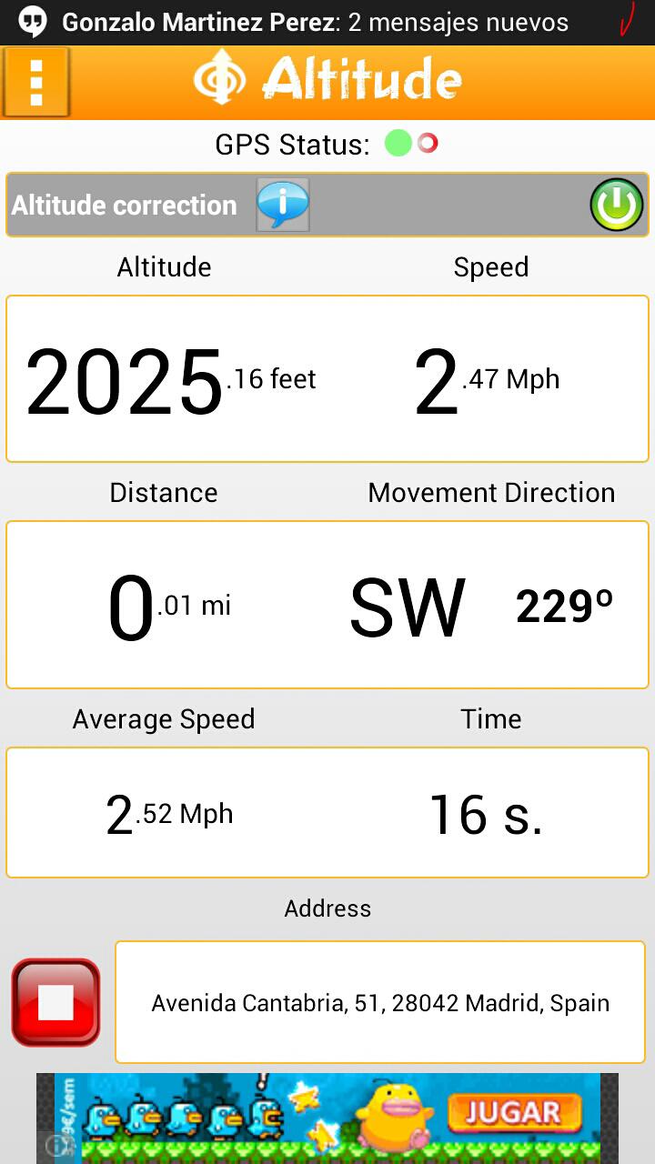
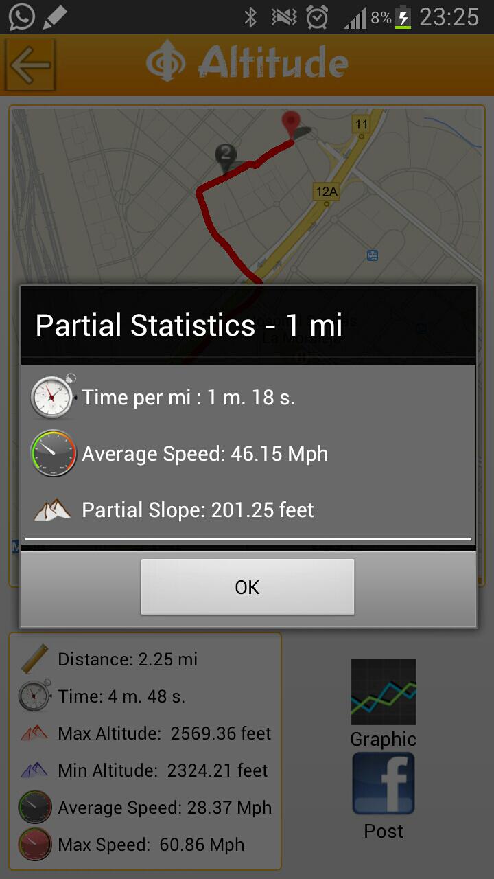
It also shows current, average and maximun speed, distance, time, direction of movement, physical address where you are, maximum and minimum height of your route and you can save them to see them whenever you want.

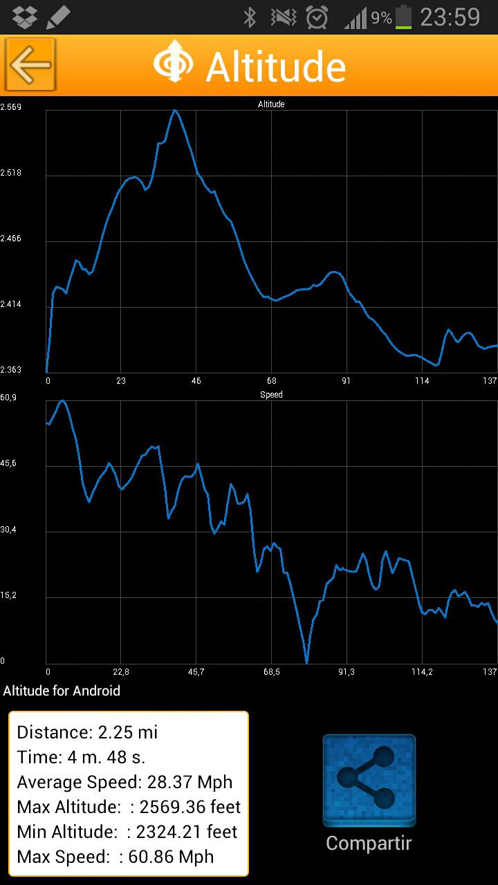
You can view your routes in Map, post them on your Facebook profile, and share them with everybody through instant messaging clients and email.

It is ideal for running, cycling, walking, hiking, skiing, go to the mountain, recording car journeys and workouts.

You can view graphs of the height and speed of all your journeys as well as partial statistics for each mile or kilometer: average speed, time, and elevation gained or lost.

It is easily configurable, and you can choose the units you want to display information: Km / h, MPH, meters, feet.

To work properly, you must be outdoor in order to receive GPS signal.

Altitude also has a compass to help you orient yourself anytime.

What's New in the Latest Version 2.09a9

Last updated on May 23, 2016 2.09
- Russian and Portuguese language added
- Various improvements

2.08
- Some improvements

2.07
- bugs fixed

2.06
- We have added the option to export your tracks to GPX format so that you can see your tracks outside the application.
- Graphics have been improved. The X axis is now the distance.
- Performance improvements.

2.05
- We have added a compass to help you orient yourself anytime.

Download(2.76MB)
Users also viewed
  • Metro date uccw skin

    Metro date uccw skin

    1.1 July 5, 2025
  • Vejret Nu

    Vejret Nu

    1.2 July 5, 2025
  • YABRB

    YABRB

    6.9 July 5, 2025
  • Max Total Security

    Max Total Security

    26.1.18 July 5, 2025
  • Remote Command Prompt

    Remote Command Prompt

    1.0 July 5, 2025
  • Japan Weather

    Japan Weather

    0.3.6 July 5, 2025
  • My Backup

    My Backup

    2.1.33033 July 5, 2025
  • 200+ Photo Effect-Blend Effect

    200+ Photo Effect-Blend Effect

    1.0 July 5, 2025
  • Cloud Pi

    Cloud Pi

    1.0.0 July 4, 2025
  • CONTRITY ICON-FREE APEX/NOVA

    CONTRITY ICON-FREE APEX/NOVA

    1.1.0 July 4, 2025
  • Kdoor

    Kdoor

    3.2 July 4, 2025
  • EXST

    EXST

    1.1.1 July 4, 2025
  • S Pen Keeper

    S Pen Keeper

    2.0.2 build 020 July 4, 2025
  • SecuHome

    SecuHome

    2.5.7 July 4, 2025
  • MH4U Info

    MH4U Info

    1.0 July 4, 2025
About Privacy Policy Terms of Service Cooking Policy

© Copyright 2017-2025 downzr.com